This was always going to be a critical week for a $500 million freeway project in the Rose Quarter.
For more than 18 months, the Oregon Department of Transportation and Portland City Hall have been trying to sell the public on a project that would add a continuous lane to Interstate 5 in each direction between I-84 and I-405. April 1 marked the end of a required public comment period, when people could raise objections.
The government agencies expected a few fender benders. But the comment process has turned into a flaming wreck—perhaps bad enough to sabotage the project for years.
ODOT and City Hall expected Portland's alternative transportation activists to oppose the project. But in March, big institutional players began jumping on the critical bandwagon: establishment environmental groups, Portland Public Schools' board, Albina Vision chairwoman Rukaiyah Adams, and the regional government Metro.
And they've chipped away at the project's friendly façade. In the days leading up to the deadline, multiple key ODOT claims have crumbled under inspection.
Here are three:
Claim: ODOT says the project is just adding "ramp-to-ramp (auxiliary) lanes and shoulders." It isn't a highway widening or about creating more "capacity."
Critique: Metro says ODOT's central document, called an environmental assessment, has some serious problems, including the basic question of what the project would and would not do. "This statement is not objectively true and is potentially misleading; auxiliary lanes clearly add capacity," wrote Elissa Gertler, Metro's director of planning, in an April 1 letter.
And Joe Cortright, an economist and volunteer for the group No More Freeways, has pointed out a potentially bigger problem: ODOT's own planning document "discloses that the project is engineering a 126-foot-wide right of way, sufficient to accommodate an eight-lane [highway]," writes Cortright in an April 1 letter. "Once this project is complete, only restriping would be required to have eight lanes."
Claim: The environmental assessment says the project would help move cars through the area faster, reducing emissions.
Critique: Observers argue that more cars would arrive if more blacktop is available for them. And parents at nearby Harriet Tubman Middle School aren't convinced air quality would improve.
"The overwhelming academic literature on air pollution from transportation suggests that decongestion pricing, and not freeway expansion, is the best policy to improve local air pollutants and mitigate the impacts of freeways on their surrounding communities," wrote six parent leaders at Tubman. Portland Public Schools' board joined them, asking ODOT to go back to the drawing board and do a longer, more complete assessment of the project, called an environmental impact statement.
Claim: The project would benefit bicyclists and pedestrians in Portland, not just motorists.
Critique: Lots of groups have argued that bike routes and other changes the project would make to local streets are flawed: The project includes widening a section of Northeast Broadway to five lanes, and getting rid of an overpass that's a key bike route.
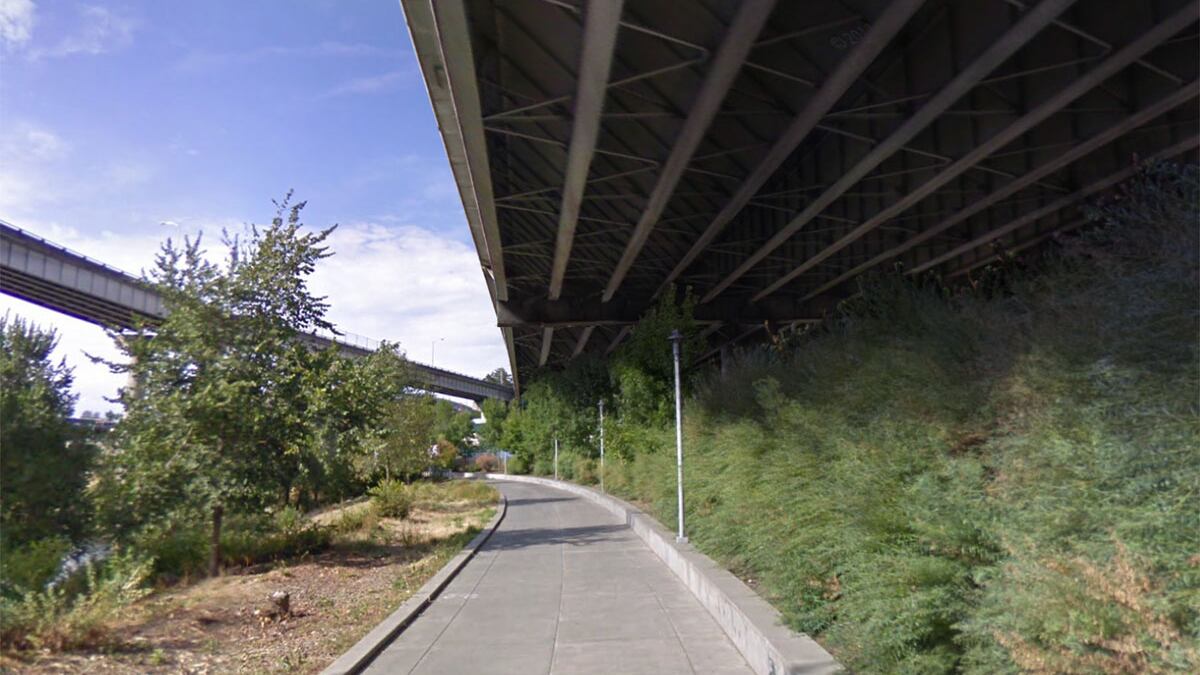
But perhaps most troubling was the disclosure of what the Vera Katz Eastbank Esplanade would look like if the highway were widened. In a simulation prepared by a local firm once ODOT released maps and engineering drawings, the esplanade looks more like a cave than an outdoor bike and walking path—because the new lanes of I-5 jut out over the riverfront bike path and walkway. (One wag suggested the built-in roof would make the esplanade the perfect spot for a homeless shelter.)


ODOT dissembled when first asked for engineering drawings by the architect Iain Mackenzie and then revealed them after a public records request. The official ODOT document prepared to assess the impacts of the project says the area "would not be adversely affected."
Mackenzie is skeptical. "It is difficult to see how widening a freeway viaduct directly adjacent to a park facility, or perhaps even over it, cannot be an adverse affect," Mackenzie wrote in a March 31 comment.