Multnomah County officials said Saturday that the 59 deaths from extreme heat last weekend were most prevalent at the southeast edge of Portland, in a section of the city that previous reporting has shown contains more than its share of concrete and far fewer trees.
County officials released only minimal details about who died in 110-degree temperatures between June 26 and 28. On Sunday, after this story published, the county raised the official too to 64 people.
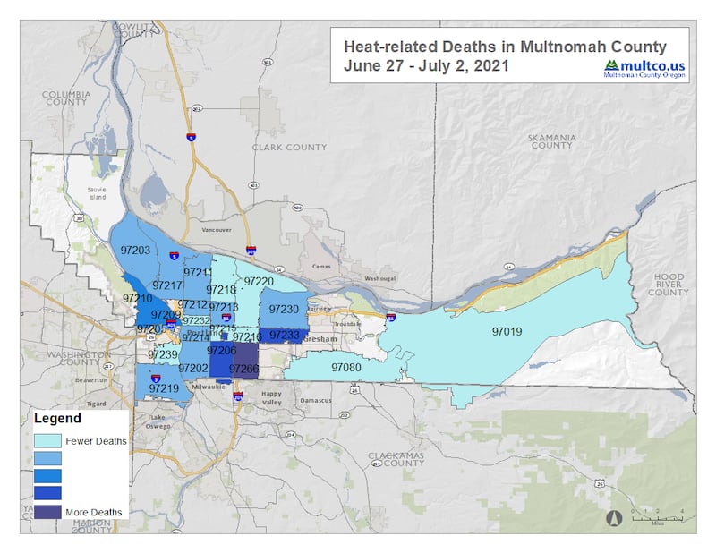
The county provided a map of where people died and shaded the county using five different hues of blue and purple to show where the most people died. The lightest shade of blue was denoted as “fewer deaths” and a dark purple was denoted as “more deaths”—the most severe metric on the county’s scale.
What constituted “more” and “fewer” was not explained, and the county declined to release specific numbers. (Officials said no ZIP code experienced more than five deaths.)
The only chunk of town shaded in the deep purple was the ZIP code 97266 in East Portland, which includes the Lents and portions of the Powellhurst-Gilbert neighborhoods.
The two ZIP codes shaded with the next highest number of deaths were 97206, a ZIP code in deep East Portland that flanks 97266 to the west, and 97233, also in deep East Portland and bordering Gresham.
The concentration of heat deaths around the Interstate 205 corridor tracks with a Portland State University study, reported by WW in 2019, that showed these neighborhoods were packed with “heat islands”—patches of concrete that trapped heat during the day and released it at night, never allowing the neighborhood to cool down.
Similarly, WW reported last year on a stark disparity in the city’s tree canopy, leaving East Portland neighborhoods far more exposed to the sun.
The three neighborhoods the county indicated had experienced the most deaths last weekend corresponded with the places WW reported had more heat islands and fewer trees.
County officials said they had confirmed that 30 of the 59 deaths during the heat wave were from hyperthermia—that is, overheating. That’s more than double the number of hyperthermia deaths (12) in the three years between 2017 and 2019.
The county said that 52 of the 59 people who died were white.
Ninety-five percent of the deaths were reported on or after Monday, June 28, the county said. The dead include 20 women and 39 men.
“Many people had underlying health conditions and many of those who died were found alone, without air conditioning or a fan,” the county said in a news release. “The majority of people died in their homes, but at this stage, we are not able to release the exact number of people experiencing homelessness because of missing information and because establishing homelessness takes intensive death investigation and follow-up.”