In the summer, Sauvie Island is Portland's favorite rural retreat. Situated just 10 miles north of the city proper, it's an easy getaway for beachgoers—particularly those looking to lounge in the buff—and u-pickers hoping to score some fresh produce. Even at its most crowded, the vibe is still bucolic and sleepy.
In the winter months, though, the island gets even sleepier. The beaches and hiking trails are pretty much empty, and there's no line of traffic searching for parking spots. Sure, there's a bit less to do—even the most dedicated exhibitionist will think twice about stripping down and frolicking in the Columbia when it's 45 degrees and drizzly. But there's still winter bird watching: There are 250 bird species that can be seen on the island throughout the year, and in late winter, there's still a chance to catch sandhill cranes before they migrate north.
Oh, and there's also a crashed UFO hiding in the weeds just off shore.
Wapato Access Greenway State Park
One of the many places in and around Sauvie Island with prime bird watching, Wapato Access Greenway State Park sits along the Multnomah Channel and has a 2.2 mile trail that takes you through a dense forest of bigleaf maples and Douglas firs. The trail loops around Virginia Lake, where you'll see waterfowl. The lake is seasonal, so during summer the water recedes and becomes more or less a wetland. There are two bird watching platforms and sign posts throughout the trail that tell you about the different bird species you might encounter. Be sure to bring binoculars and also keep an eye out for other wildlife, such as beavers and coyotes. There's no parking permit required at this trailhead.
Directions: From 405 North, take Exit 3 for Highway 30 W and St. Helens. Continue on Highway 30 for 8.5 miles and then turn right on NW Sauvie Island Rd. Drive about another 2 miles until you reach Wapato Access Greenway State park on your left.
Oak Island Nature Trail
Part of the Sauvie Island Wildlife Area, Oak Island is only open to hikers seasonally, April 16 through September 30. One of the best times to visit, however, is right when the trail opens for the season, when migrant sandhill cranes might still be present. At the junction by the gate, head left and take the 2.5-mile loop, which winds through tall grassy meadows and oak forests. Oregon white oak trees can live up to 500 years, and serve as a critical habitat for a number of wildlife, including insects, birds and small mammals like TK AND TK. You'll pass Steelman Lake on your left and then Sturgeon Lake, where blue herons can be seen year-round. From the shore of Sturgeon Lake, on a clear day, you can get a glimpse of Mount St. Helens. Then continue on the trail before turning right, passing a bench and a memorial plaque. You'll eventually pass through an oak forest and turn left at the junction back toward the parking lot. Parking permit required.
Directions: From 405 North, take Exit 3 for Highway 30 W and St. Helens. Continue on Highway 30 for 8.5 miles and then turn right on NW Sauvie Island Rd. Continue about 2 miles and then turn right onto NW Reeder Rd. After about a mile keep left to continue on NW Oak Island Rd. Drive 3 miles and keep right to stay on NW Oak Island Rd. Go about another half mile and then take a slight left to stay on NW Oak Island Rd. The trailhead will be on your left.
Warrior Rock Lighthouse Trail
Warrior Rock Lighthouse is a far cry from the imposing structures on the coast—it is, in fact, the smallest lighthouse in Oregon, and one of only two in the state not located on the Pacific Ocean. Built in 1889, it originally had an oil lamp beacon and a fog bell, though the bell was destroyed when the lighthouse was struck by a barge in 1969. Both are now automated, as the lighthouse continues to guide boats along the Columbia River.
The out and back hike to the lighthouse skirts along the Columbia River through a cottonwood forest, with plenty of great views to make the trip worthwhile. You'll come to a junction shortly after starting the hike and you'll want to bear right as there's a tree sign here directing you to a trail towards the lighthouse. If you come during the rainy season, be prepared for a particularly muddy hike. After 3 miles, you will reach Warrior Rock Lighthouse. Perched on a bed of basalt rocks, the lighthouse is also an ideal place to stop and take a rest before hiking back. Make sure to step around the lighthouse to check out the giant bird mural. Parking permit required.
Directions: From 405 North, take Exit 3 for Highway 30 W and St. Helens. Continue on Highway 30 for 8.5 miles and then turn right on NW Sauvie Island Rd. Continue for about 2 miles and then turn right onto NW Reeder Rd. Drive 13 miles and the trailhead will be at the end of the road.
Racoon Point and Viewing Platform
Another place to stop and take a rest, Racoon Point and Viewing Platform are both located off Reeder Road and offer excellent views of wintering duck and goose flocks. There are also swans, waterfowl and birds of prey in the area. From the gravel parking lot at Racoon Point, a short path will lead you to a bench and an overlook with a pond and a couple of interpretive signs that detail the various birds at Racoon Point. The Viewing Platform, also great for bird watching, is a short drive away—located past Milepost 7 on Reeder Road, on the left side beyond the trailer park. Parking permit required.
Directions: From 405 North, take Exit 3 for Highway 30 W and St. Helens. Continue on Highway 30 for 8.5 miles and then turn right on NW Sauvie Island Rd. Continue for about 2 miles and then turn right onto NW Reeder Rd. Continue about another 3 miles and Racoon Point will be at Milepost 3 on your left.
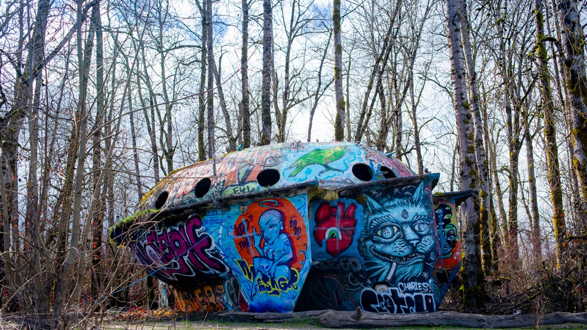
The Collins Beach UFO Boat
In 1996, an extraterrestrial spacecraft washed up on the shores of Sauvie's clothing-optional beach. In truth, it's actually an experimental concrete sailing boat created in the early 1970s by engineer Richard Ensign. Years before it became a local attraction, it was a functioning vessel that could sleep 12 people and had a wood stove. Its maiden voyage lasted three months, but it ultimately ran aground and was abandoned. A flood deposited it above the shoreline, where it now exists sheltered by the trees and covered in trippy graffiti art, including a blue cat smoking a joint, a heart with an eyeball and, of course, a green alien. Parking permit required.
Directions: From 405 North, take Exit 3 for Highway 30 W and St. Helens. Continue on Highway 30 for 8.5 miles and then turn right on NW Sauvie Island Rd. Continue for about 2 miles and then turn right onto NW Reeder Rd. After 11 miles you'll reach Collins Beach. Park at the 3rd entrance and take the path in. The boat will be on your right.