There are few places left in this state that feel as solitary as the Oregon Badlands.
Out in the heart of the wilderness area’s 45 square miles, it’s possible you won’t come across any other hikers. Even in spring—the ideal time to visit a landscape that’s snowy in the winter and blisteringly hot in the summer—the trailheads are almost never crowded.
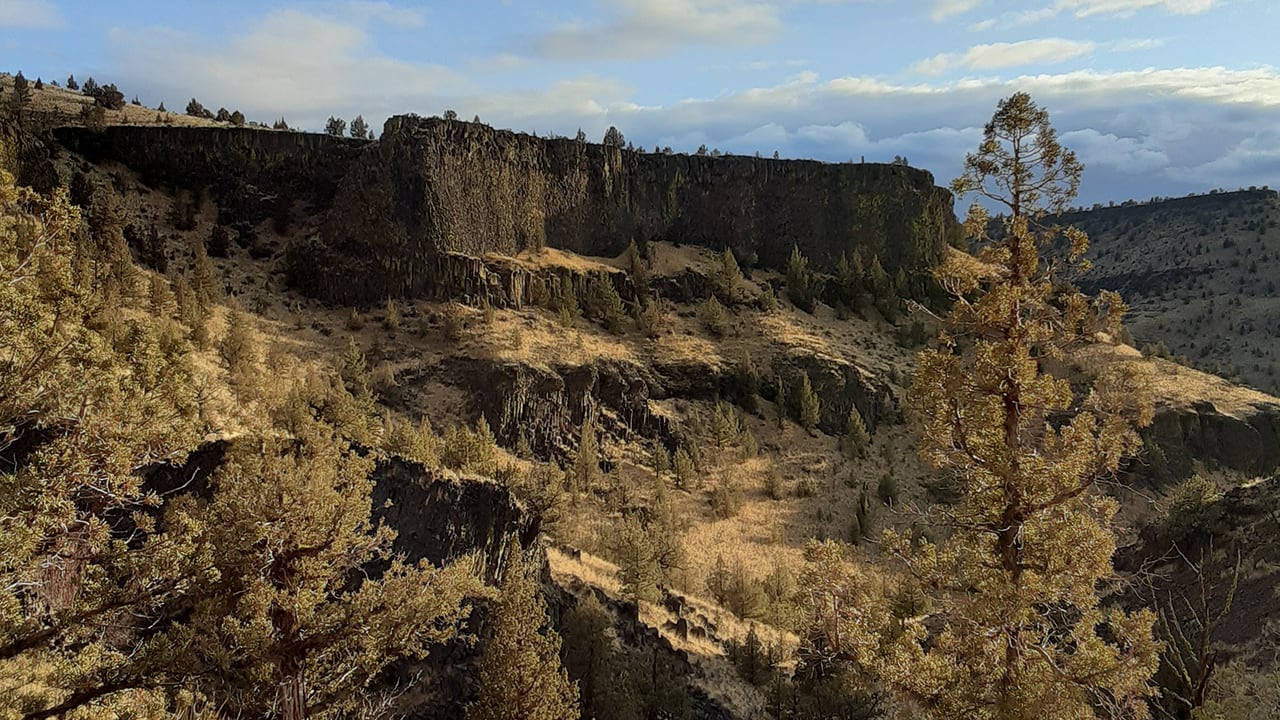
It’s one of the most unique ecosystems in the region. Located just a short drive south of Bend, Oregon’s Badlands were formed by a dramatic mix of fire and ice, including an Ice Age river, three volcanoes and a fault line that busted up one of the volcanoes, a history that only makes the Badlands’ present-day stillness all the more stark.
But you don’t need to research the area’s Pleistocene geology to appreciate its beauty. Besides, the results of those ancient events remain plenty visible.
An island of sand in the middle of arid ranch land, much of the Badlands’ soft soil was deposited by the explosion of Mount Mazama, which blew its top off thousands of years ago, creating Crater Lake. The rocky ridges that line the trails were built by ancient lava flow, and the junipers that grow out of the cracked basalt are some of the oldest in the state.
Wandering the wide, expansive landscape is a surreal experience. On a clear day, you can see the snow-capped Sisters Mountains rising above the rugged landscape. The flatness of the trails makes the sprawl of sage, juniper and blue sky feel endless. The beauty is in the details, making you slow down to appreciate the intricate shape of twisted junipers, lichen-covered rocks and the bird songs that break up the solitude. It’s vast, sparse and strangely captivating—and the fact that it’s so still and quiet makes it all the more exciting when a jackrabbit suddenly darts across the trail, or a golden eagle passes overhead.
Sure, it’s not the lush, dramatic beauty of hikes on the west side of the state where there’s a waterfall around every corner. But it’s a must for connoisseurs of desolate landscapes, and those looking to escape the increasingly large crowds in Oregon’s state parks.
The Trail to Take: Tumulus Trail
The Flatiron Trail is the most popular, and for good reason—it shows off some of the coolest rock formations in the Badlands. But if you’re coming from Bend or the Crooked River and want to shave off some travel time, the trails that are accessible from the Tumulus trailhead are just as worthwhile. Just over 30 minute from either location, the trail is a 7-mile out-and-back, or you can take a short 4-mile, lollipop-shaped route that consists of the Tumulus, Basalt and Black Lava trails. Though it’s basically flat, don’t be surprised if your miles per hour are much lower than usual. The soft, sandy soil can make for slow going.
What to Bring
Along with the basics you’d bring on any hike, be sure to carry plenty of sunscreen and water. There’s no water at all beyond the trailhead—the canal water near the trailhead definitely isn’t potable—and you’ll be in full sun for basically the entire hike, unless you pull off the trail to take a break under a juniper. Binoculars are great to have, too: The Badlands are home to mule deer, antelope, bobcats and over 100 species of birds, including the bizarre and elusive sage grouse.
Where to Stay
Camping isn’t allowed in the Badlands, but it’s just a short drive from Bend. Better yet, the Crooked River is lined with campsites, and only about a 20-minute drive from the trailheads at the north end of the park. A three-hour drive from Portland—though closer to four if you avoid the winter conditions on Highway 26—the area is overseen by the Bureau of Land Management, and the seven campgrounds are all tucked under juniper trees along the river. The Chimney Rock Campground is particularly beautiful, offering stunning views of the river and tree-dotted canyon cliffs. For BLM camping, the sites are pretty luxe—there’s a picnic table and fire pit at each one. All the campgrounds are drive-up and first-come, first served, costing $8 per weeknight and $12 on weekends.
Also Check Out:
The Crooked River is worth exploring in and of itself. Just across the road from Chimney Rock Campground is the Chimney Rock Trailhead, a short 3-mile round trip to and from the top of the canyon, where you’ll get sweeping views up and down the river and all the way to the Sisters Mountains.
Directions: If you can drive through the snow and ice by Mount Hood, take US 26 east to US 97 south. Once you reach Redmond, take US 126 east to Powell Butte Highway. Turn left onto Alfalfa Road and continue on to Johnson Ranch Road, which takes you to the Tumulus Trailhead. To avoid snowy conditions, take Interstate 84 west to the Dalles, where you’ll get on US 197 south. Continue straight on to US 97.