The name certainly doesn't inspire much confidence.
If you've never driven across the lengthy Astoria-Megler Bridge—which peaks at almost 200 feet above the Columbia to provide enough clearance for massive freighters before skimming the water the final few miles into Washington—you probably haven't seen Cape Disappointment. And with such a discouraging moniker, you may question whether it's worth a visit.
But the "disappointment" here has nothing to do with the jagged promontory's views. In fact, a good rule of thumb for destinations along the Oregon Coast is the more dubious the name, the more breathtaking the view—see Devils Punchbowl or Cape Foulweather. Often, the boiling bay or precarious peak in question earned that distinction because the seascape is so stunning it presents a hazard to mariners. And Cape Disappointment is no different.
The headland where the Columbia River meets the Pacific Ocean is one of the most treacherous bar crossings in the world. It was slapped with its label by an English captain who basically missed his turn. John Mears, who sailed near the cape in 1788, couldn't find the river's entrance, assumed it was a bay and called the whole mission a bust.
Whatever sort of deterrence the name had for early explorers, visitors today aren't fooled. Campsites and picnic tables tend to fill quickly on summer weekends. But even though every grassy lot was blooming with pitched tents on a visit in early July, few of those occupants opted to take the more challenging route to get to the state park's Lewis and Clark Interpretive Center. Hiking the trail rather than driving the road to the viewpoint may take a bit longer but rewards with the kind of scenic variety that can only be found on the Pacific Northwest coastline: towering old-growth forest, lapping waves and even a military battery carpeted in moss.
From the Waikiki Beach Trailhead parking lot, begin with a short detour down to its namesake. It looks nothing like the better-known strip of golden sand and glitzy skyscrapers in Oahu, but this place boasts its own beauty, and with fewer crowds. The small cove is sheltered on either side by a jetty and a giant cliff face. And while the shore may be several shades of gray, depending on the sunlight, it's covered in a tumble of driftwood, inviting fort builders of all skill levels to start drawing up plans.
After assessing where you'd like to set up your temporary beach shelter, post-hike, walk back toward the fee booth where you entered (Discovery Pass, $10) until you reach a sign for the Cape Disappointment Trail to the right. From there, push up a fern-lined hill that spills out onto a small bluff above Waikiki Beach, revealing an even bigger supply of scattered lumber. It's not long before you duck back into the forest, passing under alder and spruce trees cloaked in lichen that dangles like cobwebs.
About a half-mile in, you'll spot signs of human-made structures that have long been obsolete. These are the remains of Fort Canby, established in the mid-1800s as a harbor defense for the Columbia and maintained until the end of World War II. Scamper up a cement staircase that nature is trying to reclaim for a peek at boat traffic and the long arm of the North Jetty reaching across the water. In another half-mile, you'll stumble upon a gun battery with a roof sprouting a wild mane of spiky ferns. You're free to use the old cannon fortress as an archeological playground, but do so with caution—the dark corner rooms and pointy, rusted, doorless hinges can trip you up if you're not paying attention.
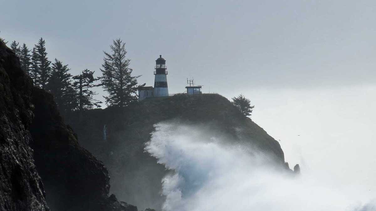
If there is any sort of actual letdown on this hike along Cape Disappointment, it's that the Coast Guard cut off trail access in June to the lighthouse, which was completed in 1856 and is the oldest operating in the Pacific Northwest. But you still get a stunning perch at the interpretive center from which to view the weathered structure.
Now you're just shy of the southernmost point on Washington's coastline, and on the edge of a continent that feels like the end of the world. The swirling river below won't let you soon forget that last part.
Cape Disappointment
Distance: About 2.5 miles
Difficulty: Parks scare me. (1 out of 5)
Drive time from Portland: 2 hours, 15 minutes
Directions: From Astoria, cross the Astoria-Megler Bridge and turn left at the end to take Highway 101 north, toward Ilwaco/Long Beach. After about 2 miles into Ilwaco, turn left onto 2nd Avenue Southwest, which becomes Robert Gray Drive. Follow that for about 2 miles. Turn right onto Fort Canby Road, which then veers slightly right and becomes Jetty Road. Continue straight through the pay station and you'll spot the parking lot.