BY MICHELLE DEVONA
Just a few weeks ago, we watched in horror after learning our beloved Columbia River Gorge had fallen victim to a massive wildfire, which was still burning at press time.
While it may just be another wildfire to some, it's a tragic loss for those of us who sought refuge among the lush forest trails and waterfalls. However, we have good news for those still grieving. There are still awesome waterfall hikes on the Washington side of the Gorge that are totally worth the trip, some of which do not get nearly as much foot traffic—or didn't before this.
Here are a few of our favorite waterfall hikes that haven't been affected
by the fire.
1. Cape Horn Loop – 7.1 miles
40 minutes from Portland: Take I-5 North and turn right on WA-14 after crossing the Columbia River. Head east to Milepost 26, turn left on Salmon Falls Road, and use the parking lot on your immediate right.

One of the more adventurous and varied hikes in the Gorge, Washington's Cape Horn Loop takes you along lush forest, idyllic countryside and by a few pleasant waterfalls. The lower portion of the trail is closed from Feb. 1 to July 15 to protect nesting peregrine falcons, so you'll need to go while it's open if you're hoping to see waterfalls. Start from the trailhead, where you'll soon climb a series of steep switchbacks through a forest of bigleaf maple and some patches of wildflowers.

The loop includes several dizzying overlooks, where you'll see Oregon points of interest like Angels Rest and Coopey Falls. You'll also get a panoramic Gorge view at Phoca Viewpoint, a stone amphitheater perched above the highway that eyes Multnomah Falls and Mist Falls across the river. You'll also hit a section with some tall grassy meadows and pastoral farmland where, if you're lucky, you can catch a glimpse of some horses. After the countryside, you'll again snake through forest before eventually ducking a highway underpass, and this is where the trail begins to get more wild and rugged.
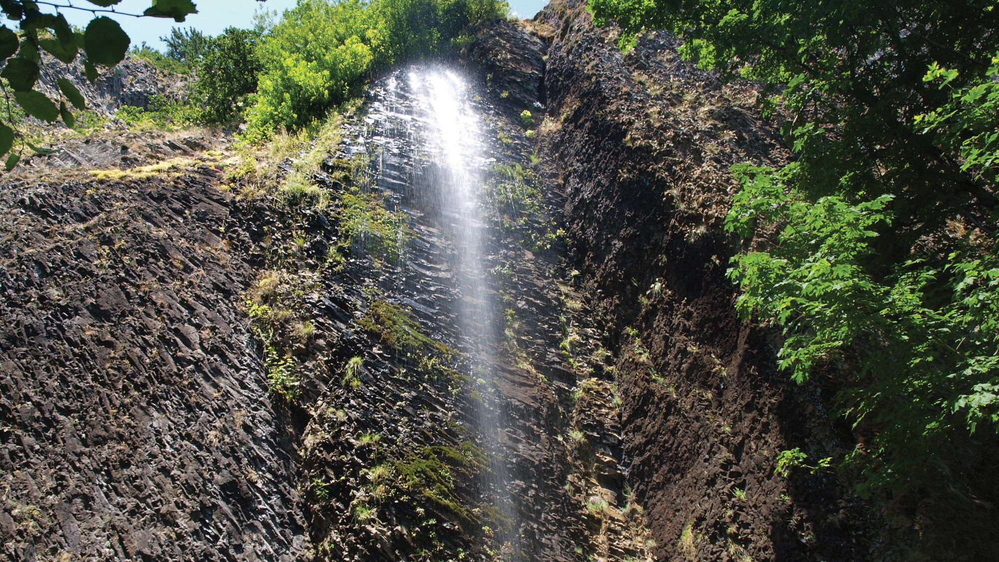
The loop's lower portion zigzags several switchbacks with river vistas and some mossy scree slopes where you'll see a couple of waterfalls. Just as your legs begin to turn to jelly, you'll come to a footbridge facing Cape Horn Falls, which you can actually walk behind, although this involves a slight ascent to the waterfall base. The waterfall resembles more of a shower than anything else, sprinkling down onto a bed of rocks. Afterward, you'll continue down the steep, rugged trail before meeting Cape Horn Road, a paved street that leads you through a rural residential area back to the trailhead.
2. Hamilton Mountain Loop – 7.5
60 minutes from Portland: From I-84 East, take Exit 44 and cross the Bridge of the Gods ($2 toll). Turn left onto WA-14. After about 7 miles, you'll see the parking area for Beacon Rock on your left. Make a right up the hill, and the trailhead parking lot will be on your right. $10 Discover Pass required.

Right across from Beacon Rock, the Hamilton Mountain Trail has pretty much everything going for it when it comes to Gorge hikes, what with rushing waterfalls, cliffs, epic views and deep forest. During the warmer months, you may come across Oregon grape, thimbleberry and wild rose while in the fall you'll see an undertone of yellow maples poking out from behind green firs. Begin with a moderate climb up a trail lined with second-growth Douglas fir and then under some power lines before reaching a bench where you can catch your breath and enjoy views of Hamilton Mountain and Bonneville Dam.
A little farther down, you'll find a side trail that descends to a somewhat tree-obscured view of Hardy Falls, one of the three waterfalls on this hike. The two others, Pool of Winds and Rodney Falls, await not far ahead. Hardy Creek gushes from 50 feet above into the rock-formed pool that is Pool of Winds, and if you stand right next to it, you'll be welcomed with a powerful yet refreshing spray. FYI, you're going to get a bit wet, but it's the ultimate in-your-face waterfall experience, one in which you can get up close and personal rather than simply admire from afar. From the footbridge, you'll see Rodney Falls, the second tier created by Pool of Winds, as it cascades down a mossy rock water slide.
After the bridge, be ready to switchback uphill before meeting a junction with Hardy Creek Trail, where you'll decide whether to take the high road by continuing the steeper ascent up Hamilton Mountain, with cliff-edged vistas of Mounts Hood, Adams and St. Helens and Table Mountain, or go with the easier Hardy Creek Trail without as many views. Either way, it's safe to say you've earned yourself a pint (or several) after this one.
3. Falls Creek Falls Loop – 6.2 miles
90 minutes from Portland: From I-84 East, take Exit 44 and cross the Bridge of the Gods ($2 toll). Turn right onto WA-14 and continue about 6 miles before making a left onto Sprague Landing Road. Continue straight to stay on Wind River Highway before making a right onto Meadow Creek Road/NF-30. In less than a mile, turn right onto NF-3062 and continue 2.4 miles to the trailhead. Note: Use extra caution when driving on NF-3062; it's a gravel road and, at the time of this writing, had a few potholes.
Cloistered within Gifford Pinchot National Forest, Falls Creek Falls is a whimsical three-tiered waterfall often overlooked. The gently graded trail hugs the creek for the first mile, giving way to a tranquil sun-dappled hike. You'll reach a suspension bridge that crosses a section where the creek channels through a narrow basalt canyon. The trail continues to weave along the creek and takes you past giant old-growth firs and cedars while down below the current makes it way around tight little canyons and rocks.

As you approach Falls Creek Falls, the powerful sound of water thundering down is heard before it's even within view, and a cool misty breeze pervades the area once you're there. Even more lush greenery clings to the rocks around the falls, which make it seem more surreal than anything else. So much so the entire scene could easily pass as cover art for a cheesy romance novel, sans heroine and flowing-hair dude. After admiring the falls, head back the way you came and you'll soon arrive at a junction that gives you the option to ascend a steep trail to the top of the falls. While only the very top of the waterfalls are within sight here, there are some killer views of the mountains and valley below. To complete the loop, return via Upper Trail 152. FYI, the road leading to this trail is closed Dec. 1 to April 1, so if you go then, add another 4 miles to the trail. Bonus: Panther Creek Falls is only about a 30-minute drive from Falls Creek Falls Trailhead (below).
4. Panther Creek Falls Hike – .3 miles
75 minutes from Portland: From I-84 East, take Exit 44 and cross the Bridge of the Gods ($2 toll). Turn right onto WA-14 and continue about 6 miles before making a left onto Wind River Highway toward Carson. Drive 5.8 miles before turning right onto Old State Road for the Panther Creek Campground. Continue 0.1 miles and then turn left onto Panther Creek Road. Stay on this road for another 7.5 miles and you'll see a large gravel parking lot on the right. Park there and walk back down the direction you came. You'll soon see a large spray-painted sign on the road for Panther Creek Falls.
Yet another stunning waterfall quietly tucked within the Gifford Pinchot National Forest, Panther Creek Falls is a nice little hike that you can pair with nearby Falls Creek Falls. While there's no official street sign that marks the trailhead, you'll see a huge arrow spray-painted in the road pointing to the trail. Just walk down the gently graded gravel trail until you hit the viewing platform for Panther Creek Falls. From here, you can observe the upper section of the falls, where Panther Creek plunges down a channel and transforms into a veil of waterfalls cascading over a mossy rock face.
There's another small portion of the falls that escapes the channel and drops right down, eventually merging with the other falls before tumbling into the pool below. If you're feeling adventurous, you can take on the somewhat sketchy scramble leading down to the base of the falls, which is only recommended if you have some off-trail hiking experience.
It's also suggested you bring a rope if you want to do the climb to the waterfall base since it's such a steep descent. If you do make it down, you can see the true grandiosity of the falls as it plummets from high above. For folks who would like to make a weekend out of it, there's camping during the summer months at the Panther Creek Campground, which is about four miles south of Panther Creek Falls.

We Hiked the Reopened Timberline Trail That Circumnavigates Mount Hood. It's a Beast.
Not Ready For a 40-Mile Hike? Try These Bite-Sized Chunks of the Timberline Trail
Four Great Waterfall Hikes That Haven't Been Affected by the Eagle Creek Fire
Gorge No More: Sites And Hiking Trails Damaged By The Eagle Creek Fire
Here's Where to Donate to Help Victims of the Eagle Creek Fire
The Eagle Creek Fire Is Terrible—But What Comes Next Is Both Natural and Beautiful
Petr Kakes is a Legendary Character of Skibowl's Warming Hut—And Maybe a Little Bit Crazy
These 11 Portland Shops Can Outfit You for Your Mount Hood Adventures